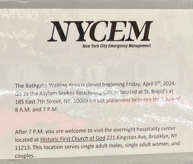

Photo by: Marc Fader
Despite being located on an island, the city’s Rikers jail complex is in a no-evacuation zone on the city’s risk map, suggesting that even a severe hurricane wouldn’t pose a threat–at least to the areas of the island where inmates live.
In August, as the city was scrambling to prepare for what many were predicting to be a potentially devastating hurricane, controversy arose over what was otherwise an innocuous answer at a press conference: There would be no evacuation of Rikers Island, Mayor Bloomberg said.
After a prisoner advocacy blog called Solitary Watch posted something about the mayor’s announcement—drawing comparisons to stranded prisoners left behind in New Orleans during Hurricane Katrina—a number of other websites followed suit, along with a few traditional news outlets. Twitter users caught on shortly after; a petition demanding the city take action was circulated. Many were struck by the fact that while the city was shutting down its transportation system and making other unprecedented storm plans, the some 14,000 people housed on Rikers Island would stay put.
Irene came and went, however, and with a wet whimper instead of a bang. The ten jail facilities on Rikers came through unscathed, as the mayor’s office and the Department of Correction repeatedly said they would, and it seems as though the jail was never in any real danger from the storm to begin with. But the incident raised a question that received little public attention before: how the city would deal with the tens of thousands of inmates on Rikers, an island accessible by only one bridge, should an emergency arise.
“Whether they had to evacuate Rikers or not during Irene, they’ll have to evacuate eventually,” says Dr. Irwin Redlener, director at the National Center for Disaster Preparedness at Columbia University’s Mailman School of Public Health. “The key point is, do they have an effective evacuation plan at the jail? And to my impression they do not.”
A no-flood zone?
The Office of Emergency Management’s hurricane evacuation map color-codes low-lying areas as either Zone A, B, or C—from the highest risk of flooding from a hurricane storm surge to the lowest risk. Rikers, 96 acres nestled in the East River between Queens and the mainland Bronx, is shown as all white, meaning at no risk of flooding.
“The vast majority of Rikers Island is located in a No Flood Zone,” Department of Correction spokeswoman Sharmen Stein wrote in an e-mail.
“Only one facility is located in Zone C—the first floor of that one jail may be vulnerable to some flooding, but is not susceptible to loss of life. In that instance, the inmates and staff assigned to the first floor would be relocated to higher floors in the jail, or moved temporarily to other facilities on Rikers Island. It is only a narrow portion of the outer perimeter of the island—where there are no jails—that might be vulnerable to flooding, even in a Category 4 hurricane.”
Klaus Jacob, a research scientist at Columbia University’s Lamont-Doherty Earth Observatory and a member of the mayor’s New York City Panel on Climate Change, says that in the event of a 100-year storm—a magnitude of storm that, statistically speaking, has a one percent chance of happening in a given year—”only a small fringe of the island” would flood.
He added that New York State emergency maps, like the city’s map, show portions of the island at risk of flooding should a category 3 or 4 hurricane occur, while other portions of the are shown as above any flood zone.
“It seems understandable that an evacuation was not warranted for Irene since it did not make a hurricane category 1, nor did it make a 100-year storm,” Jacob says. Indeed, Irene was downgraded to a tropical storm by the time it hit New York.
An enormous undertaking
The decision to evacuate a correctional facility, experts say, is a tremendously complicated one, dependent on a number of factors and hypothetical situations.
“The evacuation plan is going to be based upon the speed they need [to move], how much time they have, the resources they need to make it happen,” says Rick Mathews, Director of the National Center for Security and Preparedness at SUNY Albany. “Where are you going to take them to? How far away?”
Stein, at the DOC, denied previous news reports that the department has no evacuation plan for the facilities on Rikers, insisting that the department is “continually reviewing and refining its contingency plans,” and that these include the consideration of both small scale relocations and an evacuation of the entire population of the island, if need be. She would not comment on specifically where inmates would be transferred to in that case, citing security reasons.
“We would relocate as much of the population as the situation requires,” Stein wrote in an e-mail.
Martin Horn, former commissioner at the DOC who left the department in 2009 for a teaching position at John Jay College, says that the department met with the OEM following Hurricane Katrina to revamp its emergency plans. These included evacuation, he says, but under extreme circumstances.
“[We] concluded that it would be a very, very difficult exercise, and it would take a more severe storm than what we experienced this time,” Horn explains. “Getting tens of thousands of inmates off of Rikers Island is an enormous undertaking, and not something you do quietly.”
An evacuation of that magnitude would take, at a minimum, 48 hours to carry out, Horn estimates. The realistic difficulties of carrying out such a task, he says, led the department to conclude that a “defend in place” plan is the most viable, with the possible evacuation of more vulnerable inmates—the elderly, ill, or expectant mothers. At any given time, Rikers is equipped with enough fuel and food to self sustain for at least seven days, he says.
According to Mathews, the risks posed by a large-scale evacuation can sometimes outweigh the benefits, making staying put the better option, if it’s a viable one.
“A lot of these facilities, particularly correctional facilities, because they’re designed to keep people in and secure, are much more stable. They’re able to withstand assaults like a category 1 storm,” he says. “A lot of the times it’s safer to shelter in place than to risk the movement.”
Spread the risk
In a post-9/11 world filled with hypothetical worst case scenarios, Rikers Island seems especially at risk for emergency, considering its large population, the fact that there’s only one route in and off of the island and its proximity to LaGuardia Airport.
“Rikers, because of its physical location, and the logistics with respect to getting to and getting from the island being so fragile, puts it in a really special category,” says Redlener. “Not only is it a vulnerable population but it’s also in a vulnerable location with a lot of unusual challenges.”
“My worst fear always was something at LaGuardia,” says Horn. “My worst-case scenario was some sort of explosion, and fumes drifting over.”
During his time as commissioner, Horn wanted to reduce the population of Rikers Island, transferring inmates to jails in the other boroughs, to locations more easily accessible.
“I felt it was better to distribute the risk,” he explains.
For several years, the city planned to open a 2,000-plus bed jail facility in the South Bronx to absorb that number of inmates from Rikers. Plans for the proposed Oak Point Detention Center were officially squashed in 2008, however, after opposition from local groups and elected officials.
Another plan, to expand the recently reopened Brooklyn Detention Center to nearly double its capacity, was also dropped last summer after a firestorm of criticism. The DOC’s most recent plans call for the Brooklyn facility, and another in Kew Gardens, Queens, to be “fully utilized,” but not expanded.
The construction of a new, 1,500-bed jail on Rikers is being planned for completion in 2017, and several older buildings will be taken down with its opening—ultimately reducing the capacity at Rikers by around 3,000 inmates, according to the DOC.